|
The Indian Analyst
|


North Indian Inscriptions |
ALAMPUNDI PLATE OF VIRUPAKSHA. 1307. We do not know from other sources that, at this time, he had already extended his dominions to that part of the country. The earliest inscriptions of Harihara II. that have hitherto been discovered in the south, are dated in Śaka-Saṁvat 1315.1 Consequently, it is at least doubtful if the date of the Âlampûṇḍi plate can be looked upon as genuine. If the week-day were mentioned in the date, it could be verified by an expert, and the result of such verification would help considerably in deciding whether the grant is genuine or not. The omission of the week-day and of the names of the donees may also be urged against the genuineness of the document. The orthographical as well as calligraphical mistakes in which this small inscription abounds, and the uncouth language and construction which, to a casual reader, render it difficult to say who the actual donor was,— Harihara, Virûpâksha, or Jannâmbikâ,— are other facts which may be urged against the genuineness of the plate. On the other hand, we cannot definitely pronounce the inscription to be a forgery, because the date, Śaka-saṁvat 1305 (for 1307), actually falls into the reign of Harihara II., who in verse 4, is spoken of as if he was living at the time of the grant.2 In spite of the doubts which may thus be reasonably entertained as to its genuineness, the grant is interesting as the first known copper-plate inscription in Grantha characters, professing to belong to the Vijayanagara dynasty.
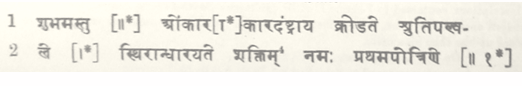
......The object of the grant, Âlampûṇḍi, is identical with the village in which the plate is still preserved. Âlampûṇḍi was situated in the district of Cheñchi, which formed part of the country of Palakunrakkôṭṭam, which was also called after Chiṁkapura (v. 9). According to Mr. Crole’s Chingleput Manual, page 438, Palakunrakkôṭṭam was situated in the North Arcot district. But the present inscription shows that a portion of the South Arcot district was also included in this kôṭṭam. Chiṁkapura is probably the same as Śiṅgavaram near Gingee in the Tiṇḍivanam tâlukâ (No. 146 of the Taluk Map), and Cheñchi is a Saṅskṛitised form of Śeñji, vulgo Gingee, the site of a well-known hill-fort. The boundaries of Âlampûṇḍi were :— In the east, Tânriêntala ; in the north, the Vêganadî (river) ; in the west , Śaktimaṅgala ; and in the south, Mâbhuvilliênatala. Of these, Śaktimaṅgala has to be identified with Śattiyamaṅgalam (No. 84 on the Taluk Map), which is situated to the south-west of Âlampûṇḍi. The northern boundary, the Vêganadî, does not retain its old name. On the Tindivanam Taluk Map there is a river marked as flowing to the north of Âlampûṇḍi, but its name is given as Varâhanadî. The same river is mentioned in the Manual of the South Arcot District, where another name of the river is also given, viz. the Gingee, which is evidently derived from the town of Gingee, close to which the river flows in its lower course. Consequently, the Vêganadî of the inscription has to be identified with the Varâhanadî of the Taluk Map. Tânriêntala is a Sanskṛitsed form of the Tamiḷ name Tânri-êndal, which means ‘a hill on which tânri trees grow.’ The last portion of the name of the southern boundary, ênatala, is also a corruption of the Tamil word êndal, ‘a hill.’ But neither Tânri-êndal nor Mâbhuvilli-êndal can be traced on the Taluk Map. ......In the Manual of the South Arcot District, the colophon Śrî-Harihara is explained as the signature of king Harihara II. As, however, all other Vijayanagara grants conclude with the name of some god as Virûpâksha, Veṁkaṭêśa or Râma, it is preferable to explain the colophon Śrî-Harihara as denoting the tutelary deity of king Virûpâksha, who made the grant. TEXT.3
......1 ante, p. 116.
| ||||||||||||||||||||||||||||||||||||||||||||||||||||||||||||||||||||||||||||
| > |
|
>
|