The Indian Analyst
 

South Indian Inscriptions


Contents

Index

Introduction

Contents

List of Plates

Additions and Corrections

Images

Contents

Bhandarkar

T. Bloch

J. F. Fleet

Gopinatha Rao

T. A. Gopinatha Rao and G. Venkoba Rao

Hira Lal

E. Hultzsch

F. Kielhorn

H. Krishna Sastri

H. Luders

Narayanasvami Ayyar

R. Pischel

J. Ramayya

E. Senart

V. Venkayya

G. Venkoba Rao

J. PH. Vogel

Index

Other South-Indian Inscriptions 

Volume 1

Volume 2

Volume 3

Vol. 4 - 8

Volume 9

Volume 10

Volume 11

Volume 12

Volume 13

Volume 14

Volume 15

Volume 16

Volume 17

Volume 18

Volume 19

Volume 20

Volume 22
Part 1

Volume 22
Part 2

Volume 23

Volume 24

Volume 26

Volume 27

Tiruvarur

Darasuram

Konerirajapuram

Tanjavur

Annual Reports 1935-1944

Annual Reports 1945- 1947

Corpus Inscriptionum Indicarum Volume 2, Part 2

Corpus Inscriptionum Indicarum Volume 7, Part 3

Kalachuri-Chedi Era Part 1

Kalachuri-Chedi Era Part 2

Epigraphica Indica

Epigraphia Indica Volume 3

Epigraphia
Indica Volume 4

Epigraphia Indica Volume 6

Epigraphia Indica Volume 7

Epigraphia Indica Volume 8

Epigraphia Indica Volume 27

Epigraphia Indica Volume 29

Epigraphia Indica Volume 30

Epigraphia Indica Volume 31

Epigraphia Indica Volume 32

Paramaras Volume 7, Part 2

Śilāhāras Volume 6, Part 2

Vākāṭakas Volume 5

Early Gupta Inscriptions

Archaeological Links

Archaeological-Survey of India

Pudukkottai

EPIGRAPHIA INDICA

the North Arcot district.[1] Kalavâ-nîvṛit is derived from the town of Kalavai in the Arcot tâluka of the North Arcot district.[2] For Paḍuvûr-kôṭṭam see above, Vol. IV. pp. 82, 138, 180, 271 ; Vol. V. p. 50 ; Vol. VII. p. 192 ; and South-Ind. Inscr. Vol. III. p. 89. The name of the village granted, Nîpataṭâka, is evidently a Sanskṛit translation of a Tamil name which should be Kaḍappêri.[3] As a matter of fact there is at present a village called Kaḍappêri in the Wâlâjâpêṭ tâluka of the North Arcot district, which is situated five miles east of the anicut or masonry dam across the Pâlâr river, and two miles south-west of Kâvêripâk itself. It is situated on the Kâvêrippâkkam channel which at present takes off from the Pâlâr river on the southern side of the anicut, and is irrigated by a branch from it. It thus retains its ancient name, notwithstanding the attempt of a king to impose on it a new one.

>

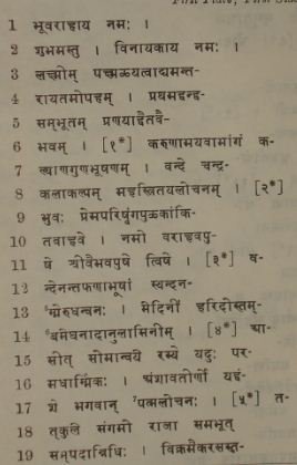
TEXT.[4]

First Plate ; First Side.

_______________________________________________________________

[1] Above, Vol. III. Additions and Corrections, p. vii.
[2] Compare above, Vol. IV. p. 271.
[3] Nîpa is the name of a tree, Nauclea Cadamba.─ [An inscription of Vîra-Kampaṇa-Uḍaiyar at Kâvêrippâkkam registers the sale of the village of Kaḍappêri in Kalavai-parru, a subdivision of Paḍuvûr-kôṭṭam ; see the Annual Report on Epigraphy for 1905-06, p. 34 No. 386 of 1905.─ V.V.]
[4] From ink-impressions.
[5] The ê of mmê is at the end of l. 12.
[6] Read
[7] Read

Home Page

>
>