|
The Indian Analyst
|
|
North Indian Inscriptions |
INSCRIPTIONS OF THE KALACHURIS OF RATANPUR RATANPUR STONE INSCRIPTION OF JAJALLADEVA I : YEAR 866 the praśasti is lost, but he was in some way related to a personage of the Kāyastha caste who belonged to a Gauḍa family and was a minister of the king Karṇa. This Karṇa is clearly the well-known Kalachuri Emperor Karṇa. His Kāyastha minister is probably identical with the one who put up the Rewa stone inscription. The writer of the present praśasti may, therefore, have been his son or some near relative. If the next verse also refers to him he seems to have owned the village Garbha¹. The praśasti was written by a person who seems to have belonged to the Vāstavya family. His name which is partly mutilated ended in –dhara². The inscription is dated, in the last line, in the year 866 (expressed in decimal figures only) on Sunday, the 9th tithi of the bright fortnight of Margasirsha. This date must, of course, be referred to the Kalachuri era and regularly corresponds, for the expired Kalachuri year 866, to Sunday, the 8th November 1114 A.C. On that day the 9th tithi of the bright fortnight of Margasirsha ended 20 h. after mean sunrise³.
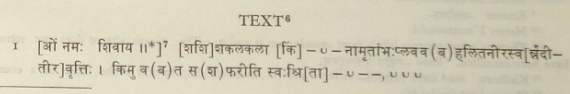
As for the geographical names in the present record, Tummāṇa, as already shown, is identical with Tumān, 26 m. north-east of Ratanpur. Kōmō-maṇḍala has already been identified. Kānyakubja is, of course, the well-known city of Kanauj, for a long time the imperial capital of North India, and Jējābhukti is Jajjhauti, the capital of the Chandēllas. Andhra is the country between the Gōdāvarī and the Kṛishṇā. Khimiḍī is probably identical with the Zamindari named Kimiḍi in the Ganjām District. It is mentioned with Kōsala (modern Chhattisgarh) in the Dīrghāsi stone inscription⁴. Vairāgara is, as shown by R.B. Hiralal, identical with Vayirāgaram mentioned in the Chōla records and is plainly identical with the modern Vairāgarh in the Chanda District, 80 m. north-east of Chanda. Lañjikā is clearly Lānji and Bhāṇāra Bhandara, the chief town of the Bhandara District of Madhya Pradesh. Talahāri is the name of the territory round Mallār as appears from the description in a record found at Mallār (No. 97, below). Daṇḍakapura may be the capital of Daṇḍabhukti which evidently comprised some portions of the Midnapur and Balasore Districts. The place may be identical with Dantan in South Midnapur District as suggested by Mr. R.D. Banerji⁵. Nandāvalī and Kukkuṭa cannot be identified. Jājallapura, which was evidently founded by Jājalladēva, may be identical with Jānjgir (Jājallanagara), the headquarters of a tahsil of the same name in the Bilaspur District. Sirulī, which was donated to the temple in Jājallapura, is probably represented by Sirli, 8 m. south-west of Jānjgir. Arjunakōṇasaraṇa may be Arjuni, 14 m. west of Jānjgir. Two other place-names Garbha and Haladī are mentioned in 1.30 of the present record. Of these, the former is also mentioned in the Raipur and Amōdā plates of Pṛithvīdēva I and may be identical with Gōbrā in the Jānjgir tahsil, while the latter is perhaps Haldi in the Bilaspur tahsil, 35 m. south-west of Jānjgir. TEXT6
1 The writer of the Raipur and Amōdā plates of Pṛithvīdēva I also was the owner of the same village.
See above, No. 75, 1.15 and No. 76, 1.39.
|
||||||||||||||||||||||||||||||||||||||||||||||||||||||||||||||||||||||||||||||||||||||||
|
|