The Indian Analyst
 

South Indian Inscriptions


Contents

Introduction

Preface

Contents

List of Plates

Abbreviations

Corrigenda

Images

Introduction

The Discovery of the Vakatakas

Vakataka Chronology

The Home of The Vakatakas

Early Rulers

The Main Branch

The Vatsagulma Branch

Administration

Religion

Society

Literature

Architecture, Sculpture and Painting

Texts And Translations  

Inscriptions of The Main Branch

Inscriptions of The Feudatories of The Main Branch

Inscriptions of The Vatsagulma Branch

Inscriptions of The Ministers And Feudatories of The Vatsagulma Branch

Index

Other South-Indian Inscriptions 

Volume 1

Volume 2

Volume 3

Vol. 4 - 8

Volume 9

Volume 10

Volume 11

Volume 12

Volume 13

Volume 14

Volume 15

Volume 16

Volume 17

Volume 18

Volume 19

Volume 20

Volume 22
Part 1

Volume 22
Part 2

Volume 23

Volume 24

Volume 26

Volume 27

Tiruvarur

Darasuram

Konerirajapuram

Tanjavur

Annual Reports 1935-1944

Annual Reports 1945- 1947

Corpus Inscriptionum Indicarum Volume 2, Part 2

Corpus Inscriptionum Indicarum Volume 7, Part 3

Kalachuri-Chedi Era Part 1

Kalachuri-Chedi Era Part 2

Epigraphica Indica

Epigraphia Indica Volume 3

Epigraphia
Indica Volume 4

Epigraphia Indica Volume 6

Epigraphia Indica Volume 7

Epigraphia Indica Volume 8

Epigraphia Indica Volume 27

Epigraphia Indica Volume 29

Epigraphia Indica Volume 30

Epigraphia Indica Volume 31

Epigraphia Indica Volume 32

Paramaras Volume 7, Part 2

Śilāhāras Volume 6, Part 2

Vākāṭakas Volume 5

Early Gupta Inscriptions

Archaeological Links

Archaeological-Survey of India

Pudukkottai

INSCRIPTIONS OF THE MAIN BRANCH


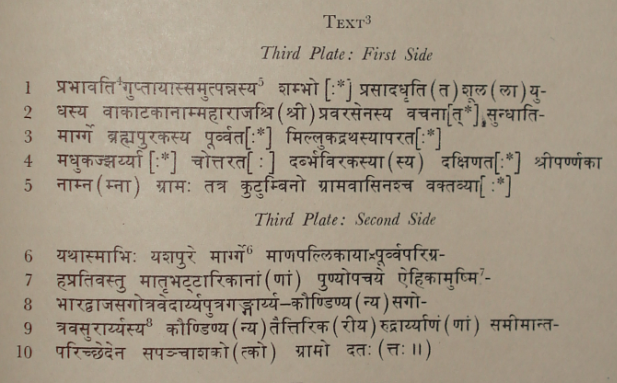
I have been able to identify some of them with the help of detailed Survey maps. BrahmaPuraka is probably Bahmanī, about 12 miles north by west of Bālāghāṭ. It lies on the road which connects Lālburrā with Samnāpur. The latter may represent ancient Sundhā or Sundhāpura, Mudhukajjharī is probably Murjhar, about 3 miles south-east of Bahmanī, and Millukadratha, modern Mugardarā, 2 miles north by east of Bahmanī. Nothing corresponding to Śrīparṇakā can be traced in the vicinity of these places, but it was probably situated between Bahmanī and Mugardarā. Darbhaviraka cannot now be traced.

...It will thus be seen that like the villages named in the Tirōḍī plates1, the villages mentioned in the present grant can be traced in the Bālāghāṭ District. As shown elsewhere, the villages mentioned in the Siwanī plates can be located in the Bhaṇḍārā District2. These identifications show that the country under the direct rule of Pravasēna II comprised the modern districts of Bālāghāṭ and Bhaṇḍārā and extended to the western boundary of Dakshiṇa Kōsala

t>

images/70

TRANSLATION
(The first two plates of this grant are not forthcoming.)

...By the order of the illustrious Pravarasēna (II), the Mahārāja of the Vākāṭakas, born of Prabhāvatīguptā, who, by the grace of Śambhu, wields a spear . . . . . .

... (Thcere is) a village named Śrīparṇakā, in the territorial division (mārga) of Sundhāti, (which lies) to the east of Brahmapuraka, to the west of Millukadratha and to the north of Madhukājjharī and to the south of Darbhaviraka. The householders and residents of the
_______________

1 Above, pp. 48 f.
2 Above, p. 29.
3 From ink impressions supplied by the Curator of the Pāṭnā Museum.
4 The dot in the superscript curve of this akshara is probably due to a fault in the copper.
5 Read प्रभावतिगुप्तायां समुत्पन्नस्यas in other cognate grants.
6 Perhaps यशपुरमार्ग्गे was intended.
7 The expression is incomplete. Read ऎहिकामुष्‍मिकहितार्थः. Cf. इहामुन्नहिताथं which occurs in several cognate plates.
8 Read यसुरार्य्य-as the drafter has used a compound containing the names of the three donees.
9 The anusvāra on this akshara may have been cancelled.

<< - 86 Page