The Indian Analyst
 

North Indian Inscriptions


Contents

Introduction

Preface

Contents

List of Maps and Plates

Abbreviations

Additions and Corrections

Images

Introduction

Political History

The Early Silaharas

The Silaharas of North Konkan

The Silaharas of South Konkan

The Silaharas of Kolhapur

Administration

Religious Condition

Social Condition

Economic Condition

Literature

Architecture and Sculpture

Texts And Translations  

Inscriptions of the Silaharas of North Konkan

Inscriptions of The Silaharas of South Konkan

Inscriptions of The Silaharas of kolhapur

APPENDIX I  

Additional Inscriptions of the Silaharas

APPENDIX II  

A contemporary Yadava Inscription

Index

Other South-Indian Inscriptions 

Volume 1

Volume 2

Volume 3

Vol. 4 - 8

Volume 9

Volume 10

Volume 11

Volume 12

Volume 13

Volume 14

Volume 15

Volume 16

Volume 17

Volume 18

Volume 19

Volume 20

Volume 22
Part 1

Volume 22
Part 2

Volume 23

Volume 24

Volume 26

Volume 27

Tiruvarur

Darasuram

Konerirajapuram

Tanjavur

Annual Reports 1935-1944

Annual Reports 1945- 1947

Corpus Inscriptionum Indicarum Volume 2, Part 2

Corpus Inscriptionum Indicarum Volume 7, Part 3

Kalachuri-Chedi Era Part 1

Kalachuri-Chedi Era Part 2

Epigraphica Indica

Epigraphia Indica Volume 3

Epigraphia
Indica Volume 4

Epigraphia Indica Volume 6

Epigraphia Indica Volume 7

Epigraphia Indica Volume 8

Epigraphia Indica Volume 27

Epigraphia Indica Volume 29

Epigraphia Indica Volume 30

Epigraphia Indica Volume 31

Epigraphia Indica Volume 32

Paramaras Volume 7, Part 2

Śilāhāras Volume 6, Part 2

Vākāṭakas Volume 5

Early Gupta Inscriptions

Archaeological Links

Archaeological-Survey of India

Pudukkottai

INSCRIPTIONS OF THE SILAHARAS OF KOLHAPUR


(expressed in words only), when the cyclic year was Vilamba. The date is quite regular. Kielhorn has shown that in Śaka 980 expired, which by the southern luni-solar system was Vilamba, the Uttarāyaṇa Saṅkrānti took place 10 h. 18 m. after mean sunrise of Thursday, the 24th December, A.D. 1058, during the 7th tithi of the bright fort-night which ended 17 h. after mean sunrise the same day.

..Of the localities mentioned in the present grant, Miriñjadēśa evidently comprised the territory round modern Miraj. Karahāṭa is modern Karhāḍ, and Kuṇḍī represents the region round modern Beḷgaon. The Khiḷigiḷa fort is evidently identical with the fort of Panhāḷā. The donated village Kuṇṭavāḍa is modern Kuṭwāḍ on the bank of the Kṛishṇā, ancient Kṛishṇavērṇā, about 21/2 miles east of Śiroḷ, corresponding to ancient Sirivōḷaḷa, the chief town of the territorial division of that name. The neighbouring villages mentioned in the present grant, viz. Kannavāḍa, Hāḍalivāḍa and Gāḷikuṭṭi are respectively identical with modern Kanvāḍ, Hasur and Ghaḷvāḍ which lie in the stated directions.
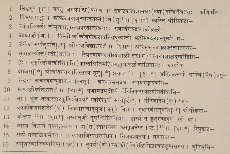
>

TEXT[1]
First Plate

images/176

________________________________________________________

[1] From the facsimiles in I.C.T.W.I.
[2] Expressed by a symbol.
[3] The daṇḍa here and in several places below is superfluou.
[4] Read द्क्त्रितय: to suit the metre Āryāgīti.
[5] Read मळयंक-to suit the metre.
[6] Metre : Śārdūlavikrīḍita.
[7] Metre : Mahāsragdharā (?)
[8] Metre : Āryāgīti (irregular).
[9] Read भुञ्जान: करहाटकुण्डिविषयं to suit the metre.
[10] Read मैरिंजेश-to suit the metre.
[11] Metre : Śārdūlavikrīḍita.
[12] Read तस्यानुजोभून्नृप- to suit the metre.
[13] Metre : Indravajrā. मळयंक-


<< - 2 Page

>
>