The Indian Analyst
 

North Indian Inscriptions


Contents

Introduction

Preface

Contents

List of Maps and Plates

Abbreviations

Additions and Corrections

Images

Introduction

Political History

The Early Silaharas

The Silaharas of North Konkan

The Silaharas of South Konkan

The Silaharas of Kolhapur

Administration

Religious Condition

Social Condition

Economic Condition

Literature

Architecture and Sculpture

Texts And Translations  

Inscriptions of the Silaharas of North Konkan

Inscriptions of The Silaharas of South Konkan

Inscriptions of The Silaharas of kolhapur

APPENDIX I  

Additional Inscriptions of the Silaharas

APPENDIX II  

A contemporary Yadava Inscription

Index

Other South-Indian Inscriptions 

Volume 1

Volume 2

Volume 3

Vol. 4 - 8

Volume 9

Volume 10

Volume 11

Volume 12

Volume 13

Volume 14

Volume 15

Volume 16

Volume 17

Volume 18

Volume 19

Volume 20

Volume 22
Part 1

Volume 22
Part 2

Volume 23

Volume 24

Volume 26

Volume 27

Tiruvarur

Darasuram

Konerirajapuram

Tanjavur

Annual Reports 1935-1944

Annual Reports 1945- 1947

Corpus Inscriptionum Indicarum Volume 2, Part 2

Corpus Inscriptionum Indicarum Volume 7, Part 3

Kalachuri-Chedi Era Part 1

Kalachuri-Chedi Era Part 2

Epigraphica Indica

Epigraphia Indica Volume 3

Epigraphia
Indica Volume 4

Epigraphia Indica Volume 6

Epigraphia Indica Volume 7

Epigraphia Indica Volume 8

Epigraphia Indica Volume 27

Epigraphia Indica Volume 29

Epigraphia Indica Volume 30

Epigraphia Indica Volume 31

Epigraphia Indica Volume 32

Paramaras Volume 7, Part 2

Śilāhāras Volume 6, Part 2

Vākāṭakas Volume 5

Early Gupta Inscriptions

Archaeological Links

Archaeological-Survey of India

Pudukkottai

INSCRIPTIONS OF THE SILAHARAS OF NORTH KONKAN


Verse 46 mentions Ammaṇaiya as an Amātya of the king, and Jhañjapaiya as his Sāndhivigrahika. The Kāyastha Uddāma, son of Chakkaiya, was the scribe.

..As for the localities mentioned in this grant, Saṁyāna, which was conquered by Aparājita, is modern Sanjān in the north of the Thāṇā District. It was preciously under the rule of an Arab feudatory of the Rāshṭrakūṭas. Puṇaka-dēśa corresponds to the modern Poonā District. Saṅgamēśvara and Chapulaṇa still retain their old names and are situated in the Ratnāgiri District. Lāṭa is the ancient name of Southern Gujarāt. The country of Bhillama is the kingdom of the Yādavas in Khāndesh. Chandrapura was probably the capital of the Chandra-maṇḍala mentioned in the Khārepāṭan plates and can be identified with Chāndor in South Goa. Mānyakhēṭa, the well-known capital of the Rāshṭrakūtas, is, of course, Mālkhed, and Karahāṭa is modern Karhāḍ in the Sātārā district. Palachchha-uchchhikā may be identical with Pālē, about three miles east of Muruḍ. Vihalē, the chief town of the territorial division in which the donated village was situated, may be Vihuli in the adjoining Māṇgaon talukā of the Kolābā District. Chikkhalāḍa, the chief town of the vishaya (district) which included these places may be identical with modern Chikhalgaon, about 8 miles north of Muruḍ. Majjigrāma, which formed the western and northern boundaries of the donated village, is undoubtedly modern Mājgaon, about 4 miles north of Muruḍ.
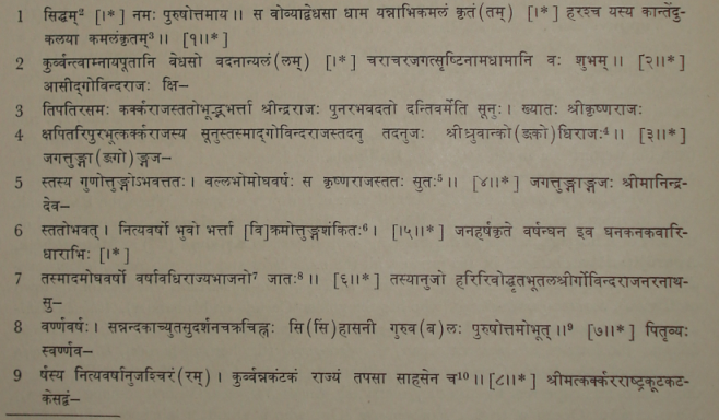
>

TEXT[1]
First Plate

images/21

_____________________________________________________

[1] From the facsimiles (Plates V-VIII) in Important Inscriptions from the Baroda State.
[2] Expressed by a symbol.
[3] Metre of this and the next verse : Anushṭubh
[4] Metre : Sragdharā.
[5] Metre of this and the next verse : Anushṭubh.
[6] The Bhādāna grant (No. 7) reads विक्रमोत्तुङ्गलक्षित:.
[7] Read - भाजनं.
[8] Metre : Gīti.
[9] Metre : Vasantatilakā.
[10] Metre : Anushṭubh.

<< - 23 Page

>
>