The Indian Analyst
 

North Indian Inscriptions


Contents

Introduction

Preface

Contents

List of Maps and Plates

Abbreviations

Additions and Corrections

Images

Introduction

Political History

The Early Silaharas

The Silaharas of North Konkan

The Silaharas of South Konkan

The Silaharas of Kolhapur

Administration

Religious Condition

Social Condition

Economic Condition

Literature

Architecture and Sculpture

Texts And Translations  

Inscriptions of the Silaharas of North Konkan

Inscriptions of The Silaharas of South Konkan

Inscriptions of The Silaharas of kolhapur

APPENDIX I  

Additional Inscriptions of the Silaharas

APPENDIX II  

A contemporary Yadava Inscription

Index

Other South-Indian Inscriptions 

Volume 1

Volume 2

Volume 3

Vol. 4 - 8

Volume 9

Volume 10

Volume 11

Volume 12

Volume 13

Volume 14

Volume 15

Volume 16

Volume 17

Volume 18

Volume 19

Volume 20

Volume 22
Part 1

Volume 22
Part 2

Volume 23

Volume 24

Volume 26

Volume 27

Tiruvarur

Darasuram

Konerirajapuram

Tanjavur

Annual Reports 1935-1944

Annual Reports 1945- 1947

Corpus Inscriptionum Indicarum Volume 2, Part 2

Corpus Inscriptionum Indicarum Volume 7, Part 3

Kalachuri-Chedi Era Part 1

Kalachuri-Chedi Era Part 2

Epigraphica Indica

Epigraphia Indica Volume 3

Epigraphia
Indica Volume 4

Epigraphia Indica Volume 6

Epigraphia Indica Volume 7

Epigraphia Indica Volume 8

Epigraphia Indica Volume 27

Epigraphia Indica Volume 29

Epigraphia Indica Volume 30

Epigraphia Indica Volume 31

Epigraphia Indica Volume 32

Paramaras Volume 7, Part 2

Śilāhāras Volume 6, Part 2

Vākāṭakas Volume 5

Early Gupta Inscriptions

Archaeological Links

Archaeological-Survey of India

Pudukkottai

INSCRIPTIONS OF THE SILAHARAS OF NORTH KONKAN


..Dr. Bühler suggested the following identifications of the localities mentioned in this Grant[1]. “The filed which was granted to Āmadēvaiya was situated in the village of Nōura, now Nōvāhar, belonging to the vishaya or tābukā of Shaṭshashṭi, the modern Salsette, and included in Śrīsthānaka or Ṭhāṇā. The village of Gōṁvaṇi is now called Gōwhan, and lies north of Bhāṇḍup. Gōrapavalī is not to be traced on the Trigonometrical Survey map, but it may be the old name of Bhāṇḍup, which occupies nearly the place assigned to Gōrapavalī[2]. It is worthy of note that the “King’s high road” (rājapatha), which according to the grant, passed to the west of the piece of land granted, followed nearly the same line as the present road from the Bombay to Ṭhāṇā.”

TEXT[3]
First Plate

images/51

>

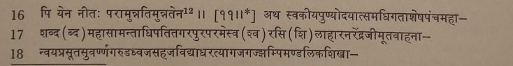
.. Second Plate : First Side

images/52

_______________________________________________________________

[1]Ind. Ant., Vol. V, p. 277.
[2] Both Nōvāhar and Gōwhan do not exist now. Fleet thought that Gōrapavalī was perhaps a hamlet (pallī) of Nōura.
[3] From the facsimiles between pages 262 and 263 in Ep. Ind., Vol. XII.
[4] Expressed by a symbol.
[5] Metre of verses 1 and 2: Anushṭubh.
[6] Metre of verses 3 and 4 : Vasantatilakā.
[7] Metre : Svāgatā.
[8] Metre : Vasantatilakā.
[9] Metre : Śārdūlavikrīḍita.
[10] Metre of verses 8 and 9 : Anushṭubh.
[11] This verse is incomplete and is incorrectly written. In place of verses 10 and 11, read तस्मादभूद्वज्जडदेवनामा श्रीकेशिदेवो नृपतिस्ततोभूत् । तद्भ्रातृजो बज्जडदेवसूनु: नृपतिर्बभूव ॥ on the evidence of v. 5 in the Dive Āgar plates of Chhittarāja (No. 10). Metre Upajāti (irregular).
[12] Metre : Indravajra.

<< - 72 Page

>
>