|
Contents |
|
Index
|
|
Introduction
|
|
Contents
|
|
List of Plates
|
|
Additions and Corrections
|
|
Images
|
|
Contents |
|
Altekar, A. S
|
Bhattasali, N. K
|
|
Barua, B. M And Chakravarti, Pulin Behari
|
|
Chakravarti, S. N
|
|
Chhabra, B. CH
|
|
Das Gupta
|
|
Desai, P. B
|
|
Gai, G. S
|
|
Garde, M. B
|
|
Ghoshal, R. K
|
|
Gupte, Y. R
|
|
Kedar Nath Sastri
|
|
Khare, G. H
|
|
Krishnamacharlu, C. R
|
|
Konow, Sten
|
|
Lakshminarayan Rao, N
|
|
Majumdar, R. C
|
|
Master, Alfred
|
|
Mirashi, V. V
|
|
Mirashi, V. V., And Gupte, Y. R
|
|
Narasimhaswami, H. K
|
|
Nilakanta Sastri And Venkataramayya, M
|
|
Panchamukhi, R. S
|
|
Pandeya, L. P
|
|
Raghavan, V
|
|
Ramadas, G
|
|
Sircar, Dines Chandra
|
|
Somasekhara Sarma
|
|
Subrahmanya Aiyar
|
|
Vats, Madho Sarup
|
|
Venkataramayya, M
|
|
Venkatasubba Ayyar
|
|
Vaidyanathan, K. S
|
|
Vogel, J. Ph
|
|
Index.- By M. Venkataramayya
|
|
Other
South-Indian Inscriptions
|
|
Volume
1
|
Volume
2
|
|
Volume
3
|
Vol.
4 - 8
|
|
Volume 9
|
Volume 10
|
|
Volume 11
|
Volume 12
|
|
Volume 13
|
Volume
14
|
|
Volume 15
|
Volume 16
|
|
Volume 17
|
Volume 18
|
|
Volume
19
|
Volume
20
|
|
Volume 22
Part 1
|
Volume
22
Part 2
|
|
Volume
23
|
Volume
24 |
|
Volume
26
|
Volume 27 |
|
Tiruvarur
|
Darasuram
|
|
Konerirajapuram
|
Tanjavur |
|
Annual Reports 1935-1944
|
Annual Reports 1945- 1947
|
|
Corpus Inscriptionum Indicarum Volume 2, Part 2
|
Corpus Inscriptionum Indicarum Volume 7, Part 3
|
|
Kalachuri-Chedi Era Part 1
|
Kalachuri-Chedi Era Part 2
|
|
Epigraphica Indica
|
Epigraphia Indica Volume 3
|
|
Epigraphia
Indica Volume 4
|
Epigraphia Indica Volume 6
|
|
Epigraphia Indica Volume 7
|
Epigraphia Indica Volume 8
|
|
Epigraphia Indica Volume 27
|
Epigraphia Indica Volume 29
|
|
Epigraphia Indica Volume 30
|
Epigraphia Indica Volume 31
|
|
Epigraphia Indica Volume 32
|
Paramaras Volume 7, Part 2
|
|
Śilāhāras Volume 6, Part 2
|
Vākāṭakas Volume 5
|
|
Early Gupta Inscriptions
|
|
Archaeological
Links
|
|
Archaeological-Survey
of India
|
|
Pudukkottai
|
|
|
EPIGRAPHIA INDICA
NARWAN PLATES OF CHALUKYA VIKRAMADITYA II
condition of the grant was that half of the dues such as aruhaṇa,[1] that were paid to Government
officers from the village Ambāḍa were to be paid from Naravaṇa. After these details come the
usual benedictions and imprecations for the preservers and violators of the grant. The record
concludes with the statement that it was written by the Mahāsandhivigraha Anivāti (Anivārita ?)
Puṇyavallabha.
The date of the grant is recorded thus ; Śaka year 664 expired, the 8th regnal year
of Vikramāditya (II), and the occasion of the Sun’s turning to the north, i.e.,
his entry into the zodiac of Capricornus. As no tithi and week-day are given, it is impossible
to verify the date. The Lakshmēśwar inscription of Śaka 656 expired gives two as the corresponding regnal year.[2] It follows that the regnal year corresponding to Śaka 664 expired will
be 10 and to Śaka 664 current will be 9, but not 8. It must, however, be remembered that the
Lakshmēśwar inscription is declared to be ‘spurious’ and as such its evidence cannot be very
much relied upon. Śaka 664 may, therefore, be either current or expired. In Śaka 664 current,
the Solar month Makara began at 22 ghaṭīs and 29 palas after mean sunrise on 21st December
741 A. D. and in Śaka 664 expired the same month began at 37 ghaṭīs after mean sunrise on 21st
December 742 A. D. The English date of the grant, therefore, would be 21st December 741
or 742 A.D.according as the Śaka year 664 is taken as current or expired.[3]
Of the place-names mentioned in this grant, it is not possible to say with any certainty
where Ādityavāḍa was. But I would just suggest that it should be tentatively identified with
one of the two Āitawaḍas in the Valwa taluqa of the Satara District. It is not known whether
the villages have any indications of antiquity ; but as its Marāṭhī pronunciation Āitavaḍe
seems to be the natural phonetic change of Ādityavāḍa (cf. Āitavāra-Ādityavāra) and as there
is no other village of this name in the Bombay Province, the identification may prove correct.
Chiprarulana appears to be the ancient name of modern Chipḷūṇ, a taluqa town in the Ratnāgiri
District, Sonnē seems to be the original name of the modern Śāstrī river flowing south of
Naravaṇa.[4] Ambāḍa is not to be traced at present.[5]Naravaṇa is a village on the seashore in
the Guhāgar Peta of the Ratnāgiri District. Chindramāḍa may be the modern Chindravla,[6]
situated some 4 miles to the north-east of Naravaṇa.
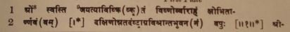
TEXT[7]
First Plate
_____________________
[1] In a Śilāhāra grant of Śaka 1037, this very word seems to occur in a slightly different form āruvaṇa (Sources
of the Mediaeval History of the Deccan, Vol. I, p. 40, l.48). It probably means a tax of six paṇas.
[2]Ind. Ant., Vol. VII, p. 107.
[3] I have calculated the point of Makara Saṅkrānti after working up to four decimals according to the Ārya-Siddhānta. According to the Sūrya-Siddhānta, the same will be 2 palas later in each case.
[4] In a Marāṭhī document of A. D. 1600 (Śivacharitra Sāhitya, Vol. II, 339, No. 340, published by the B. I. S.
Maṇḍaḷa Poona), there is a reference to the partition of a watan, the three shares of which are thus specified :
(1) Tract extending from the Bāva river to the Sōnavī river, (2) tract lying between the Sōnavī and the Gaḍa rivers,
(3) tract stretching from the Gaḍa river up to the villages Gimavī and Dēvaghara. The map of the Rātnāgiri
District shows that Bāva and Gaḍa are two tributaries of the modern Śāstrī river, which, after flowing in a more
or less parallel direction to the Śāstrī river, join it from the left and right sides respectively. Thus it is clear that
the Śāstrī river is implied by the Sōnavī river in the document or Sōnavī is the older name of Śāstrī. The word
Sōnavī has a very close affinity to Sonnē. Hence I have suggested the above identification.
[5] [This may be identical with Ambāv, a village with a branch post office attached to Dēvrukh head post office
in the Ratnāgiri District.─C. R. K.]
[6] Spelt as Chindrnole in Atlas sheet No. 25 published in 1852 A.D. by the East India Company.
[7]From the original plates.
[8] Represented by a symbol.
[9] Metre : Anushṭubh.
|


