|
The Indian Analyst
|


North Indian Inscriptions |
INSCRIPTIONS OF THE SILAHARAS OF NORTH KONKAN
was a civil war in the kingdom, taking advantage of which the Kōṅkaṇa country was overrun by the Yavanas, who harassed gods and Brāhmaṇas. But Anantapāla drove away the vile Yavanas and inscribed his fame on the disc of the moon. It seems that the Kadambas raided the Kōṅkaṇa country and they were assisted in this campaign by some Yavana chiefs ruling on the west coast. Anantapāla not only drove out the invaders, but he seems to have conquered southern Koṅkaṇ and also some part of the Goā territory. This is shown by the present grant which allows some concessions in customs duty to the merchants of Balipattana (Khārēpāṭan) in the Ratnāgiri District. Besides, Anantapāla assumed two new titles indicative of his victory over the Kadambas. One of them was Niḥśaṅka-Laṅkēśvara (the fearless lord of Laṅkā) which suggests his control over Laṅkā (part of the Gōa territory).[1] As his rule extended over the whole Koṅkaṇ country, he is referred to as Kōṅkaṇa-Chakravartin in the present grant. This title was, in imitation of him, assumed by some of his successors. ..The object of the present inscription is to record the exemption from certain customs dues and other concessions granted by Anantapāla to two merchants of Balipattana, viz. Bhābhaṇa-śrēshṭhin, who held the rank of Mahāpradhāna, and his brother Dhaṇāmaśrēshṭhin, who was the Mahāsāndhivigrahika (Chief Minister for Peace and War), when their ships and sailors entered the ports in North Koṅkaṇ such as Śristhānaka, Nāgapura, Śūrpāraka and Chēmūlya. The grant may have been made in recognition of the services rendered by these high officers in the conquest of South Koṅkaṇ and perhaps of some part of Goā[2] .. The present plates are dated on the first tithi of the bright fortnight of Māgha in the Śaka year 1016 expressed both in words and figures, the cyclic year being Bhāva. The date corresponds to the 9th January A.D. 1095. It does not admit of verification for want of the necessary details, but it may be noted that the cyclic year corresponding to Śaka 1016 was Bhāva according to the southern luni-solar system, as is stated in the present grant.
.. As for the localities mentioned in the present grant, Śrīsthānaka and Śūrpāraka have already been identified. Nāgapura may be modern Nāgāv, 6 miles south-east of Alibāg as suggested by Fleet, in the Kolābā District.[3] Chēmūlya is certainly Chaul in the same district. It is mentioned in several other inscriptions and also in the accounts of foreign travellers. Balipattana is Khārēpāṭaṇ[4].
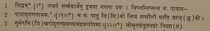
TEXT[5]
[1] This biruda had been assumed before by Mummuṇi (No. 16, lines 4-5).
|
|||||||||||||||||||||||||||||||||||||||||||||||||||||||||||||||||||||||||||||||||||||||||||||||||||||||||||||||||||||
| > |
|
>
|