The Indian Analyst
 

North Indian Inscriptions


Contents

Introduction

Preface

Contents

List of Maps and Plates

Abbreviations

Additions and Corrections

Images

Introduction

Political History

The Early Silaharas

The Silaharas of North Konkan

The Silaharas of South Konkan

The Silaharas of Kolhapur

Administration

Religious Condition

Social Condition

Economic Condition

Literature

Architecture and Sculpture

Texts And Translations  

Inscriptions of the Silaharas of North Konkan

Inscriptions of The Silaharas of South Konkan

Inscriptions of The Silaharas of kolhapur

APPENDIX I  

Additional Inscriptions of the Silaharas

APPENDIX II  

A contemporary Yadava Inscription

Index

Other South-Indian Inscriptions 

Volume 1

Volume 2

Volume 3

Vol. 4 - 8

Volume 9

Volume 10

Volume 11

Volume 12

Volume 13

Volume 14

Volume 15

Volume 16

Volume 17

Volume 18

Volume 19

Volume 20

Volume 22
Part 1

Volume 22
Part 2

Volume 23

Volume 24

Volume 26

Volume 27

Tiruvarur

Darasuram

Konerirajapuram

Tanjavur

Annual Reports 1935-1944

Annual Reports 1945- 1947

Corpus Inscriptionum Indicarum Volume 2, Part 2

Corpus Inscriptionum Indicarum Volume 7, Part 3

Kalachuri-Chedi Era Part 1

Kalachuri-Chedi Era Part 2

Epigraphica Indica

Epigraphia Indica Volume 3

Epigraphia
Indica Volume 4

Epigraphia Indica Volume 6

Epigraphia Indica Volume 7

Epigraphia Indica Volume 8

Epigraphia Indica Volume 27

Epigraphia Indica Volume 29

Epigraphia Indica Volume 30

Epigraphia Indica Volume 31

Epigraphia Indica Volume 32

Paramaras Volume 7, Part 2

Śilāhāras Volume 6, Part 2

Vākāṭakas Volume 5

Early Gupta Inscriptions

Archaeological Links

Archaeological-Survey of India

Pudukkottai

INSCRIPTIONS OF THE SILAHARAS OF NORTH KONKAN


the Bhiwaṇḍī tālukā of the Ṭhāṇā District. Nāgāmbā, which bounded it on the south, may be Nāgāva, which lies 1.60 km. to the south. Kāṭiyālaka may be Kāṭaī, which lies in its vicinity. Fleet identified Pūagambā with Pogaon, ‘half a mile east by north from Chāvindrē.’ Tōkabalāpallikā, the second donated village, cannot now be traced, but one of its boundary villages Talāvalīpallikā, may be Talavalī in the Ṭhāṇā tālukā. Similarly, Kalibalāyachōlī, which formed the northern boundary of the third donated village, may be the same as Kōlivalī about 10 km. north of Bhiwaṇḍī. The other places cannot be identified.[1]
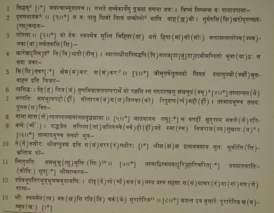
Text[2]
First Plate

images/45

>
__________________________________________________________________

[1] It seems from Fleet’s remarks in Ep. Ind. Vol. XII, p. 252, n. 2, that a transcript of the first plate of this grant was published in the Asiatic Researches, Vol. I (fifth ed.1806). That edition is not available to me.
[2] The text of the first plate is deciphered from the facsimile facing page 357 in the Asiatic Researches, Vol. I (Reprint, 1801), and that of the remaining plates is restored with the aid of the English translation of the grant in that volume (pp. 359-367) and subsequent grants of the Śilāhāras.
[3] Expressed by a symbol.
[4] Metre of vv. 1 and 2 : Anushṭubh.
[5] Read यन्मौलौ.
[6]Read रेखास्थिर्थि.
[7] Metre : Śārdūlavikrīḍita.
[8] Metre of vv. 4 and 5 : Vasantatilakā.
[9] Metre : Svāgatā.
[10] Metre : Vasantatilakā.
[11] Metre : Śārdūlavikrīḍita.


<< - 62 Page

>
>